
Province guide
Kamphaeng Phet
Kamphaeng Phet is a lower-northern province where a UNESCO-listed historic city, laterite temples, Ping River communities and forested national parks meet.
Official source · View sourceUnderstand the areas
Explore the areas within Kamphaeng Phet and find a place for your visit or everyday life.
The interactive map loads as it comes into view.
Open full map →Bueng Samakkhi DistrictBueng Samakkhi District is an administrative district (amphoe) in Kamphaeng Phet Province, Thailand.Khanu Woralaksaburi DistrictKhanu Woralaksaburi District is an administrative district (amphoe) in Kamphaeng Phet Province, Thailand.Khlong Khlung DistrictKhlong Khlung District is an administrative district (amphoe) in Kamphaeng Phet Province, Thailand.Khlong Lan DistrictKhlong Lan District is an administrative district (amphoe) in Kamphaeng Phet Province, Thailand.Explore the geographic hierarchy →
Places by type





Explore Kamphaeng Phet
Browse places by type and discover what to see and do in Kamphaeng Phet.
History & culture
Explore Thailand’s rich history through ancient ruins, landmarks and monuments.
Explore places (0) →Religious sites
Visit Buddhist temples, shrines, churches and mosques across Thailand.
Explore places (0) →Nature & scenery
Discover beaches, islands, waterfalls, caves and breathtaking viewpoints.
Explore places (0) →Parks & outdoors
Explore national parks, trails, gardens and incredible wildlife.
Explore places (0) →Public spaces
Find vibrant squares, bridges and iconic public places.
Explore places (0) →Transport
Find airports, railway stations, bus and ferry terminals across Thailand.
Explore places (0) →Local categories
Things to do
Browse local businesses and services by type.
Local categories will appear as connected listings are published.
Browse every category in Kamphaeng Phet →
Find a business or service in Kamphaeng Phet
Search published businesses and services in this area.
Businesses in Kamphaeng Phet
View more businesses →No connected businesses are published yet.
Living in Kamphaeng Phet
Explore neighbourhoods, everyday services and practical information for a longer stay.
Choose an area to learn about living in Kamphaeng Phet
Each area has its own character. Follow the local guides to learn more.
Bueng Samakkhi District
Bueng Samakkhi District is an administrative district (amphoe) in Kamphaeng Phet Province, Thailand.
Khanu Woralaksaburi District
Khanu Woralaksaburi District is an administrative district (amphoe) in Kamphaeng Phet Province, Thailand.
Khlong Khlung District
Khlong Khlung District is an administrative district (amphoe) in Kamphaeng Phet Province, Thailand.
Khlong Lan District
Khlong Lan District is an administrative district (amphoe) in Kamphaeng Phet Province, Thailand.
Compare selected areas
Everyday essentials
HealthcareHospitals, clinics and medical services.Explore →
Schools & familyEducation and everyday family life.Explore →
Shopping & marketsLocal shops, markets and essentials.Explore →
Getting aroundLocal transport, taxis and vehicle hire.Explore →
Working remotelyCoworking and professional services.Explore →
More ways to use Kamphaeng Phet
Plan the practical details
Find transport options and useful information for visiting Kamphaeng Phet.
Getting to Kamphaeng Phet
Explore routes and transport connections. Check current schedules and availability before travelling.



Getting around Kamphaeng Phet
Find local transport services and practical guidance.

Essential travel information
Weather in Kamphaeng Phet
November to February for cooler, drier heritage and outdoor visits; check national-park access and weather in every season.
Loading current conditions and forecast…
Nearby destinations
Explore more places and local guides.
Nong Pling Subdistrict
Nong Pling Subdistrict is an official tambon in Mueang Kamphaeng Phet District, Kamphaeng Phet, Thailand. · 4.5 km away
Songtham Subdistrict
Songtham Subdistrict is an official tambon in Mueang Kamphaeng Phet District, Kamphaeng Phet, Thailand. · 7.0 km away
Lan Dokmai Tok Subdistrict
Lan Dokmai Tok Subdistrict is an official tambon in Kosamphi Nakhon District, Kamphaeng Phet, Thailand. · 9.2 km away
Lan Dokmai Subdistrict
Lan Dokmai Subdistrict is an official tambon in Mueang Kamphaeng Phet District, Kamphaeng Phet, Thailand. · 9.3 km away
About Kamphaeng Phet
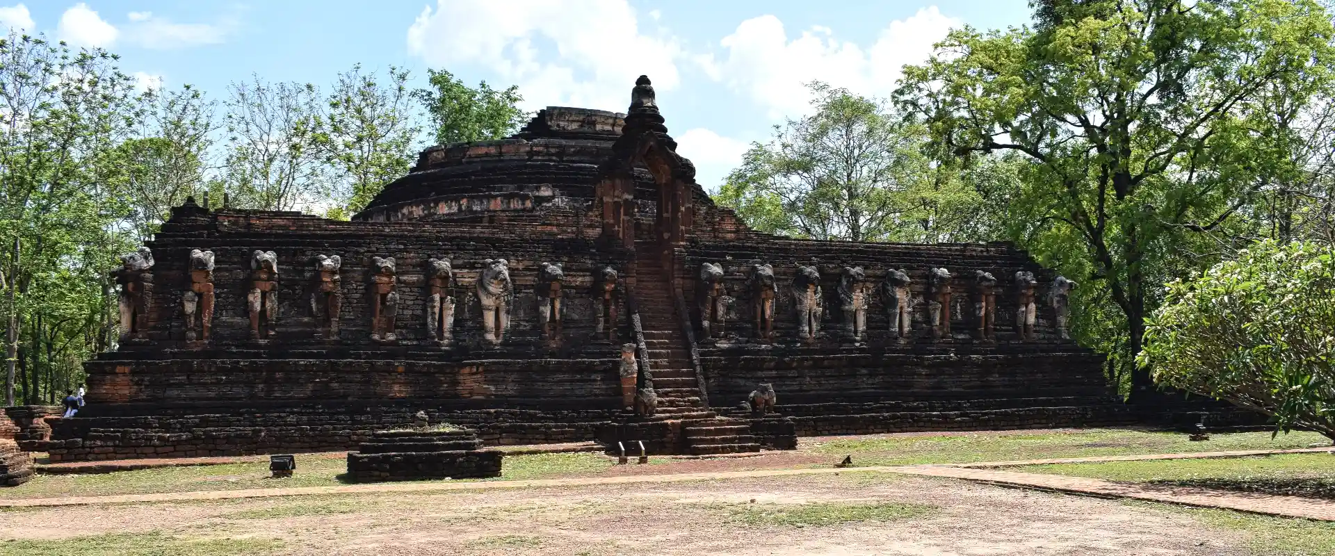
Kamphaeng Phet is a lower-northern Thai province on the Ping River, balancing major Sukhothai-era heritage with forested mountains along the western edge of the Central Plain. Kamphaeng Phet Historical Park forms part of UNESCO's Historic Town of Sukhothai and Associated Historic Towns property; its walls, moats and laterite monuments include Wat Phra Kaeo, Wat Chang Rob and Wat Phra Si Iriyabot. The provincial capital and nearby Nakhon Chum make a practical heritage base, while Khlong Lan and Mae Wong national parks draw travellers toward waterfalls, forests and high-country viewpoints.
Plan two distinct experiences. Spend a day around the historical park, museum and old communities on both sides of the Ping, then use another day for a carefully chosen western nature area. Khlong Lan District is the usual base for Khlong Lan waterfall and national-park visits; Mae Wong access requires more time and current route information. Nakhon Chum's market and local food add an evening stop, while Kamphaeng Phet's bananas and Chakungrao grass jelly are widely associated with the province. Temple ruins are archaeological sites as well as places of cultural importance, so avoid climbing structures and follow posted conservation rules.
Kamphaeng Phet covers 8,607.49 square kilometres. At 31 December 2024 it was divided into 11 districts, 78 subdistricts and 963 villages. Its registered population was 700,862 in 2024; this is the province-wide civil-registration count reported by Thailand's National Statistical Office from Department of Provincial Administration data, not the population of Kamphaeng Phet city. The province belongs in Thailand's lower northern region, and this record uses Northern Thailand as its geographic parent.
Road is the main way to reach and explore the province, with Kamphaeng Phet city positioned on the north-south Highway 1 corridor and served by interprovincial buses. Heritage sights close to the city can be combined by bicycle or local transport, but a car or arranged driver is much more practical for national parks and rural districts. November to February generally offers cooler, drier conditions for ruins and hiking; March and April are hotter, and the May-to-October wet season brings greener forests, heavier showers and possible trail or road restrictions. Check Fine Arts Department and national-park notices, carry water and sun protection, and do not build a tight onward connection around remote park travel.
- Sources
- View source
- Last reviewed
- 19 September 2026
- Content owner
- Thailand Navigator Editorial Team
- Page type
- Province guide